

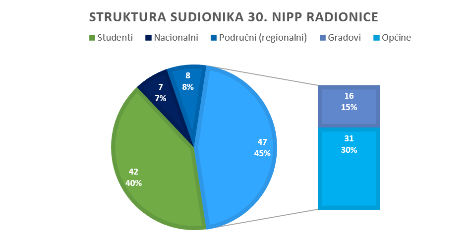
In July 2020, the State Geodetic Administration initiated activities to include local and regional self-government units in the NSDI in order to fulfill the obligations defined by the NSDI Act (OG 56/13, 52/18, 50/20). These activities are primarily aimed at organizing and holding educational NSDI workshops, and so far three cycles have been held for representatives of local and regional self-government units in which more than 280 of them participated.

The 30th NSDI workshop was opened by Antonio Šustić, Deputy Director General of the State Geodetic Administration, who emphasized on this occasion the jurisdiction of the State Geodetic Administration over three material regulations: the Law on State Survey and Real Estate Cadastre, the Law on Geodetic Activities and the Law on National Spatial Data Infrastructure. He also emphasized one of the main purposes of this workshop, which is to bring geospatial data and information closer through the National Spatial Data Infrastructure to all those who need it.
The audience was then addressed by Ljerka Marić, MsC. Head of the Spatial Data Infrastructure Sector, who emphasized the main goal of this workshop - expanding knowledge in order to effectively include local and regional self-government units in the NSDI. The program of the 30th NSDI workshop and the project "Capacity building for the establishment of the NSDI", within which the 30th NSDI workshop was held, was presented by Tomislav Ciceli, MsC, project manager.

First from a series of lectures entitled "Introduction to NSDI; Anyone can easily find, understand and use spatial data" was held by Tomislav Ciceli, MsC. This lecture presented the establishment and development of the NSDI, as well as all other components of NSDI that answer various questions about spatial data sources such as: how they originated, who is responsible for them, where they are, whether they correspond to needs, in what format are they and many others.
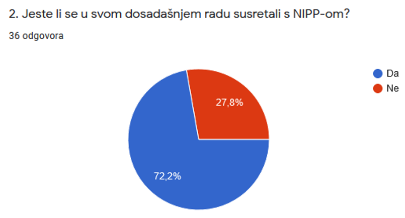
This was followed by a short interaction with the participants, achieved through an anonymous questionnaire, the purpose of which was to obtain feedback from the participants on the knowledge, understanding and use of the NSDI. The obtained results showed a good understanding of NSDI after the lecture, but also the need for additional investments in order for the benefits of NSDI to be widely recognized.
The first step in inclusion in the NSDI was presented by the lecture "NSDI Registers" by Tanja Rodin, MsC. NSDI Registers are the Register of NSDI subjects and the Register of NSDI spatial data sources, and their content is prescribed by the NSDI Act. Through this lecture, definitions of NSDI subjects and spatial data are given, as well as descriptions of NSDI themes in order to facilitate the recognition of jurisdiction over spatial data.
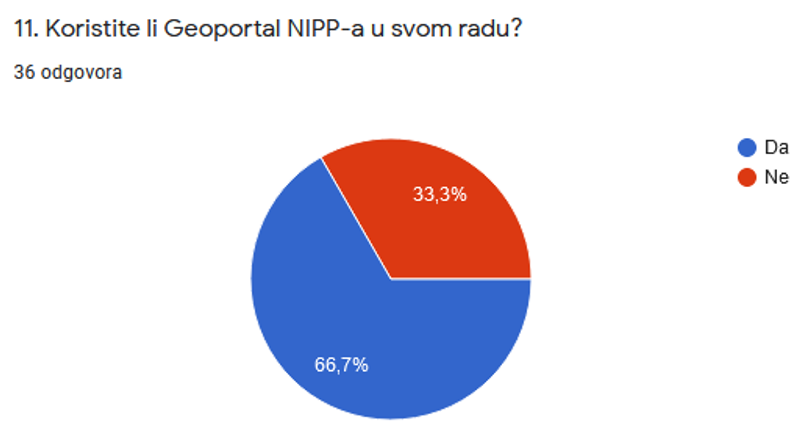
After the NSDI Registers, the next step is the entry of metadata for the reported spatial data sources under the jurisdiction of local and regional self-government units, presented by the lecture "NSDI Geoportal/NSDI Metadata Catalog" by Iva Gašparović, PhD. The NSDI Geoportal is one of the basic products of the NSDI, and this lecture presented its basic elements and functionalities. The practical entry of metadata was shown through an example according to the selected template.
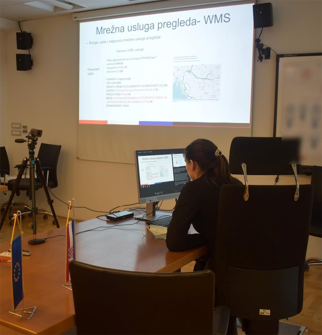
Lecture "Network Services" by Tanja Rodin, MsC, was focused on providing a quality theoretical basis on network services, and thus presented the basic standards for network view (WMS, WMTS) and download (WFS, ATOM) services, but also other available standards and network services.
The final lecture entitled "GeoHrvatska" was given by Iva Gašparović, PhD. This lecture presented the GeoHrvatska browser, one of the basic products of the NSDI intended for citizens, which is established, maintained and developed by the State Geodetic Administration.
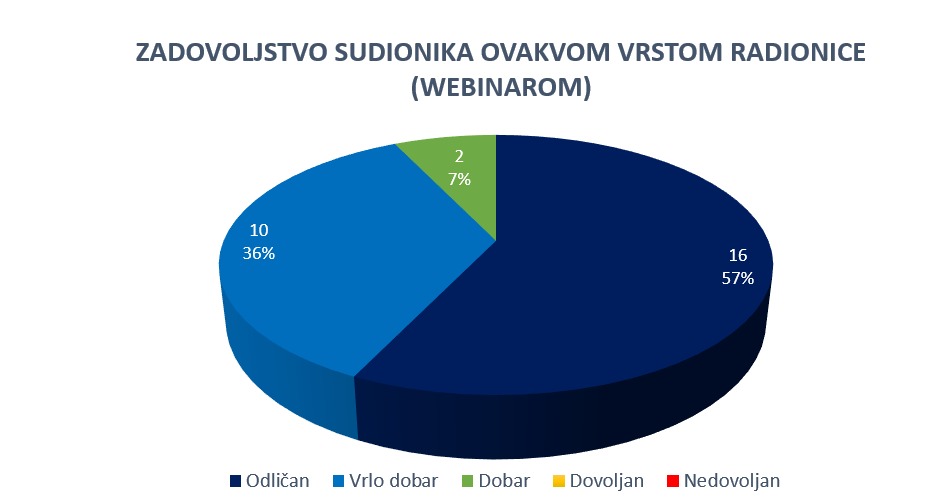
At the end of the lecture, a short discussion was held in order to resolve the doubts of the participants and further clarify certain issues, and an evaluation of the workshop was conducted by the participants, which showed that most of them rated the workshop as excellent.
The 30th NSDI workshop was organized within the project "Capacity building for the establishment of the NSDI" which is co-financed by the European Social Fund, and implemented by the State Geodetic Administration.
| 30th NSDI WORKSHOP PROGRAM | ||
| TIME | AUTHORS AND PRESENTATION TITLES | FORMAT |
| 9:30-9:35 |
Workshop opening (Antonio Šustić, SGA deputy director general) |
|
| 9:35-9:40 | Introduction to the workshop (Ljerka Marić, MSc, and Tomislav Ciceli, MSc) | |
| 9:40-10:20 | Introduction to the NSDI; Anyone can easily find, understand and use spatial data (Tomislav Ciceli, MSc) | |
| 10:20-10:30 | Interaction with participants | |
| 10:30-10:40 | NSDI Registers (Tanja Rodin, MSc) | |
| 10:40-10:55 | NSDI Metadata Catalog/NSDI Geoportal (Iva Gašparović, PhD) | |
| 10:55-11:05 | Network services (Tanja Rodin, MSc) | |
| 11:05-11:15 | GeoHrvatska (Iva Gašparović, PhD) | |
| 11:15-11:25 | Discussion | |
| 11:25-11:30 | Workshop closing | |
Access to the NSDI website from which it is possible to download forms for the purposes of project implementation (all forms are in Croatian language).
