

Metadata are an integral part of data and together they make single units. Today, the most general definition of metadata is that they are data about data. Metadata need to be documented during the collection of data and they need to be updated when data are changed. In other words, important actions related to data have to be documented through metadata.
Metadata thus became a general term referring to anything of interest. However, describing different types of resources requires different types of metadata and different metadata thematic norms. Inventarisation of everything (knowledge), made possible by metadata, is supported by computers and the amount of information computer systems can store and process, while the development of IT technologies made data sharing an everyday necessity. To be able to use shared data, different groups of users need to know the format of data, their coordinate reference system and other information that can be obtained through metadata catalogues.
There is a clear trend of developing systematic metadata cataloguing (e.g. INSPIRE and national metadata catalogues). To connect different metadata systems, there needs to be some structural link between metadata. INSPIRE was created under a strong influence of ISO metadata standardization, while Croatian NSDI metadata, except national needs, meet the INSPIRE requirements, as well.
In order for spatial data to be included in the NSDI system, they must have metadata. NSDI metadata enables: identification of spatial data sources, their categorization, determination of it position in space, estimation of its time frame, quality, access and use, whom to contact for access to data and other information. NSDI metadata is elaborated in NSDI Metadata Specification v.3.1. Each NSDI metadata has an element that compares the NSDI metadata with ISO and INSPIRE metadata, which enables the sharing and interoperability of the metadata.
Harvesting, as an operation allowing downloading metadata from a metadata catalogue, enables linking between catalogues and linking several catalogues with applications, as internet search engines do. The Dublin Core Metadata Initiative (DCMI), as a respectable international non profit organization involved in metadata standardization for various professional, thematic and business needs, differentiates between fpur levels of metadata interoperability:
- Shared term definitions defines metadata interoperability based on shared natural-language definitions. Within an application environment such as an intranet, library system, or repository, participants standardize the terms they use in the metadata system. Most existing metadata applications currently operate at this level of operability.
- Formal semantic interoperability defines metadata interoperability based on the shared formal model provided by Resource Description Framework (RDF), which is developed to support linked data that are exposed, shared, and connecting pieces of data, information, and knowledge on the Semantic Web using URI and RDF. Over the past few years, this level of interoperability has evolved significantly through the integration of public and private sector data into data clouds.
- Description Set syntactic interoperability defines metadata interoperability through applications compatible with the linked data model and, in addition, share an abstract syntax for validatable metadata records, the "description set".
- Description Set Profile interoperability defines metadata interoperability as the process by which metadata records are exchanged between applications that use metadata and further share an abstract common set od conditions, use the same dictionary, and reflect a shared model od the world. The last two levels of metadata interoperability are in the developmental or scientific domain.
Besides the basic role of metadata to describe data, those in the system of INfrastructure for SPatial Information (INSPIRE) or National Spatial Data Infrastructure (NSDI) also meet a certain functionality, i.e. business model.
ISO defines metadata as data on data, which is a general definition that does not emphasize the business model that metadata seeks to achieve. INSPIRE defines metadata as information describing spatial datasets and spatial data services allowing their finding and use.
This definition sets the goals for the business model that metadata must achieve (i.e. describe spatial data and find and use spatial data).
ISO metadata packages
Metadata packages and relations between entities
Metadata for geographic data are represented by means of UML packages. Each package contains one or more entities (UML classes) that can be specified or generalised. Entities contain elements (UML class attributes) that identify discrete metadata elements. Entities can be aggregated and repeated as needed. The figure shows the general overview of a package. Metadata are specified by a UML model diagram and data dictionary for each package
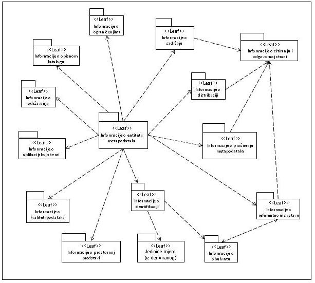
Relationship between metadata packages and metadata entities are shown in Table 6.1. Metadata packages are shown in column 'Package' and aggregated metadata entities contained within a package are shown in column 'Entity'. Each package includes sub-classes.
Relationship between metadata packages and metadata entities
| Package | Entity |
| Metadata entity set information | MD_Metadata |
| Identification information | MD_Identification |
| Constraint information | MD_Constraints |
| Data quality information | DQ_DataQuality |
| Maintenance information | MD_MaintenanceInformation |
| Spatial representation information | MD_SpatialRepresentation |
| Reference system information | MD_ReferenceSystem |
| Content information | MD_ContentInformation |
| Portrayal catalogue information | MD_PortrayalCatalogueReference |
| Distribution information | MD_Distribution |
| Metadata extension information | MD_MetadataExtensionInformation |
| Application schema information | MD_ApplicationSchemaInformation |
| Extent information | EX_Extent |
| Citation and responsible party information | CI_Citation CI_ResponsibleParty |
Package abbreviations
Two-letter abbreviations are used to denote the package that contains a class. Those abbreviations precede class names, connected by a "_".
List of Abbreviations:
| CC | Changing Coordinates (ISO 19111) |
| CI | Citation (ISO 19115) |
| CV | Coverages (ISO 19123) |
| DQ | Data quality (ISO 19115) |
| DS | Dataset (ISO 19115) |
| EX | Extent (ISO 19115) |
| FC | Feature Catalogue (ISO 19110) |
| FE | Feature (ISO 19109) |
| FT | Feature Topology (ISO 19107) |
| GF | General Feature (ISO 19109) |
| GM | Geometry (ISO 19107) |
| GR | Graph (ISO 19107) |
| LI | Lineage (ISO 19115) |
| MD | Metadata (ISO 19115) |
| PF | Feature Portrayal (ISO 19117) |
| PS | Positioning Services (ISO 19116) |
| RS | Reference System (ISO 19115) |
| SC | Spatial Coordinates (ISO 19111) |
| SI | Spatial Identification (ISO 19112) |
| SV | Services (ISO 19119) |
| TM | Temporal (ISO 19108) |
| TP | Topology (ISO 19107) |
| TS | Simple Topology (ISO 19107) |
Metadata application information
The UML class diagram in the image defines the geographic information classes that the metadata refers to.
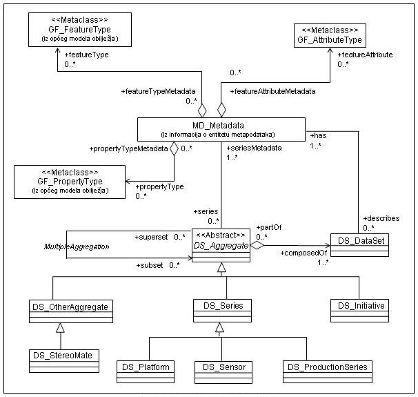
Metadata UML model
Metadata for describing geographic data is defined using an abstract object UML model. Each diagram of the subclass defines a metadata section (UML package) of related entities, data types and code lists.
Entities may have mandatory and/or optional elements and associations. In some cases, optional elements may have mandatory elements.
More information about ISO UML Diagrams:
ISO UML Diagrams Metadata package
ISO UML Diagram for identification information
ISO UML Diagram Constraint information
ISO UML Diagram for data quality information
ISO UML Diagram for maintenance information
ISO UML Diagram for spatial representation information
ISO UML Diagram for reference system information
ISO UML Diagram for content information
ISO UML Diagram for portrayal catalogue information
ISO UML diagram for distribution information
ISO UML diagram for metadata extension information
ISO UML diagram for application schema information
ISO UML diagram for extent information
ISO UML diagram for citation and responsible party information