Preskočite na glavni sadržaj
Search
Login
Login
A
A
HR
EN
NSDI
NSDI Bodies
NSDI Subjects
NSDI Themes
National contact point
INSPIRE
INSPIRE
INSPIRE Roadmap
Documents
Legal regulation
NSDI Documents
INSPIRE Documents
Working documents
Archive
Projects
Capacity building for the establishment of NSDI
Increasing the availability of NSDI spatial data through e-services
SDI DAYS 2026
Conference SDI Days 2026
Conference programme
Important dates
Events
News
NSDI conferences
NSDI workshops
Knowledge base
Frequently asked questions
Publications
Terminology
Acronyms and Abbreviations
Links
Metadata
Contact
Home
Knowledge base
Metadata
ISO UML models
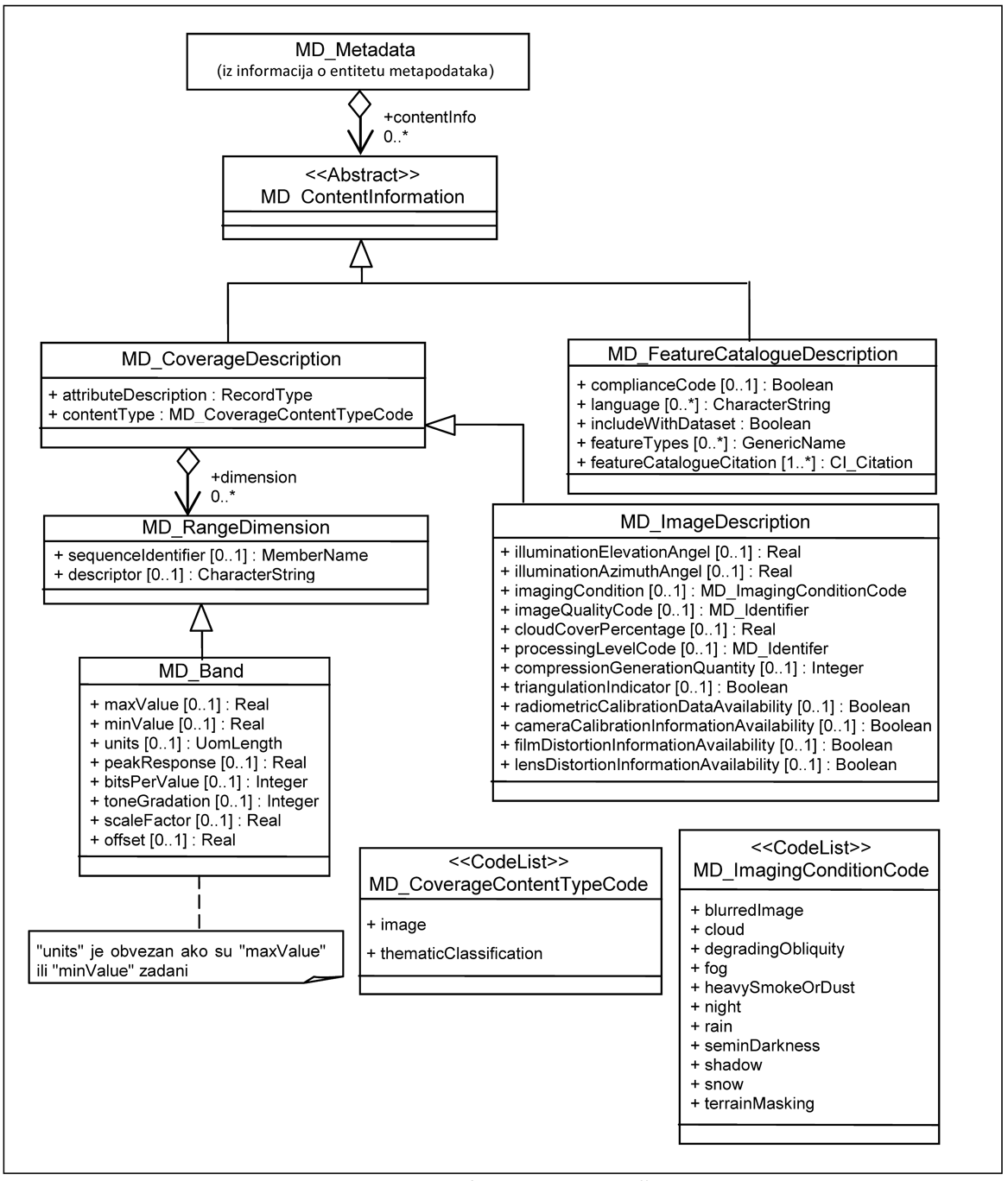
UML diagram for content information
UML diagram for content information
The following figure defines the metadata about the content of the coverage and the feature catalogue(s) used to define features.
Print
Frequently asked questions
Publications
Terminology
Acronyms and Abbreviations
Links
Metadata
Common metadata
Metadata file identifier
Resource title
Resource abstract
Alternative resource title
Unique resource identifier
Coordinate reference system
Keyword
Keyword: value
Keyword: thesaurus
Temporal extent
Reference date: date of last revision
Reference date: date of publication
Reference date: date of creation
Conditions of access and use: access
Conditions of access and use: use
Conditions of access and use: other restrictions
Limitations on public access: access
Limitations on public access: other restrictions
Responsible party
Responsible party role
Geographic location: western - most geographic longitude
Geographic location: eastern - most geographic longitude
Geographic location: southern - most geographic latitude
Geographic location: northern - most geographic latitude
Metadata point of contact
Metadata date
Metadata language
Conformity: specification
Conformity: explanation
Conformity: degree
Baseline metadata for datasets and dataset series
Resource type
Scope
Resource locator: URL
Keyword
Data format
Resource language
Topic category
Update: frequency
Update: note
Lineage
Spatial resolution: equivalent scale
Spatial resolution: distance
Interoperability metadata for datasets and dataset series
Coordinate reference system
Temporal reference system
Spatial representation type
Character Encoding
Topological Consistency: Quantitative results
Topological Consistency: Descriptive results
Linked service metadata for data sets and data set series
Protocol
Application Profile
INSPIRE View Service linking
INSPIRE Download Service linking
Baseline metadata for Spatial Data Services
Coordinate Reference System
Spatial resolution
Resource type
Service type
Scope
Resource locator: URL
Keyword: spatial data service category
Coupled resource
Metadata for Network Services
Service type
Metadata for Invocable Spatial Data Services
Service type
Resource locator: Description
Conformity: specification
Conformity: explanation
Conformity: degree
Service category: specification
Service category: explanation
Service category: degree
Metadata for Interoperable Spatial Data Services
Technical restrictions
Custodian
Quality of service: Criteria
Quality of service: measurement - description
Quality of service: measurement - value
Quality of service: measurement - unit of measure
Metadata for Harmoised Spatial Data Services
Invoke service metadata: operation name
Invoke service metadata: computer distribution platform
Invoke service metadata: endpoint
Overview-Datasets and Series
Overview-Services
NSDI XML metadata schemas
ISO UML models
Metadata package UML diagrams
UML diagram for identification information
Constraint information
UML diagram for data quality information
UML diagram for maintenance information
UML diagram for spatial representation information
UML diagram for reference system information
UML diagram for content information
UML diagram for portrayal catalogue information
UML diagram for distribution information
UML diagram for extension information
UML diagram for application schema information
UML diagram for extent information
UML diagram for citation and responsible party information
Data Dictionary for Metadata
MD_CharacterSetCode<
>
MD_ScopeCode<
>
MD_Identifier<
>
CI_Citation<
>
CI_Date<
>
CI_DateTypeCode<
>
RS_Identifier<
>
MD_TopicCategoryCode<
>
Classification of spatial data services according to EN ISO 19119 standard
MD_MaintenanceFrequencyCode<
>
MD_RestrictionCode<
>
CI_ResponsibleParty<
>
CI_Contact<
>
CI_Telephone <
>
CI_Address<
>
CI_OnlineResource<
>
CI_ OnLineFunctionCode<
>
CI_RoleCode<
>
Coordinate reference systems
NSDI spatial data theme
MD_Format<
>
LimitationsOnPublicAccess<
>
MD_SpatialRepresentationTypeCode<
>
DQ_EvaluationMethodTypeCode<
>
SpatialDataServiceType<
>
Categories of invocable spatial data services
Quality criteria for interoperable spatial data services
QualityOfServiceCriteria<
>
DCPList<
>