


28th NSDI workshop was opened by Damir Šantek, PhD, director general of the State Geodetic Administration. On this occasion, he pointed out one of the basic activities of the SGA as the primary creator of spatial data, and then the unification and distribution of spatial data of all state bodies of the Republic of Croatia, but also the SGA's obligations to the European Commission regarding NSDI implementation. The participants were also addressed by Ljerka Marić, MsC, Head of the Spatial Data Infrastructure Sector, who referred to the misdemeanor provisions of the NSDI Act (OG 56/13, 52/18, 50/20) which defines according to Article 33 “if the NSDI subject causes damage, for which the Republic of Croatia is responsible under European Union law, by its actions or non-fulfillment of obligations prescribed by this Act, the costs of such damage shall be borne by the NSDI subject.”.
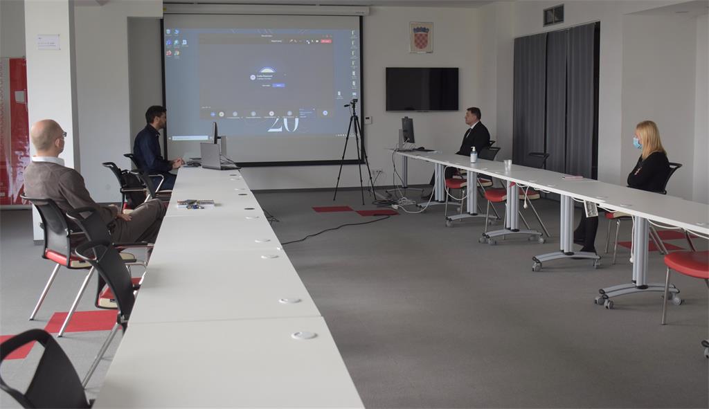
Tomislav Ciceli, MsC, Head of the NSDI Service, also greeted all present by presenting the project and program of the 28th NSDI workshop, and then continued with the first, introductory lecture entitled "Introduction to NSDI; Anyone can easily find, understand and use spatial data." This lecture emphasized the importance of real-time spatial data availability, which has proven to be extremely important in recent events, primarily earthquakes, but also floods, fires and epidemics. Due to all the above, it is necessary to establish a National Spatial Data Infrastructure that includes spatial data sources of public authorities so that they are available to citizens, but also to encourage the mutual use of spatial data sources between NSDI subjects, instead of each institution creating its own spatial sources, which significantly saves money and time.
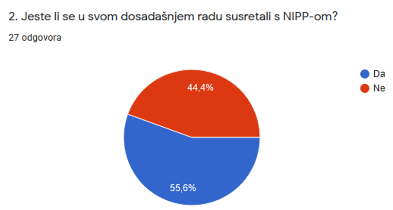
The introductory lecture was followed by a short questionnaire, designed to provide feedback from participants on knowledge and understanding of the NSDI, and the type, format and other information describing the sources of spatial data within the jurisdiction of NSDI subjects. Significant answers were obtained to the second question from the questionnaire, which show that a large part of the participants, 44.4%, have not encountered NSDI in their work so far.
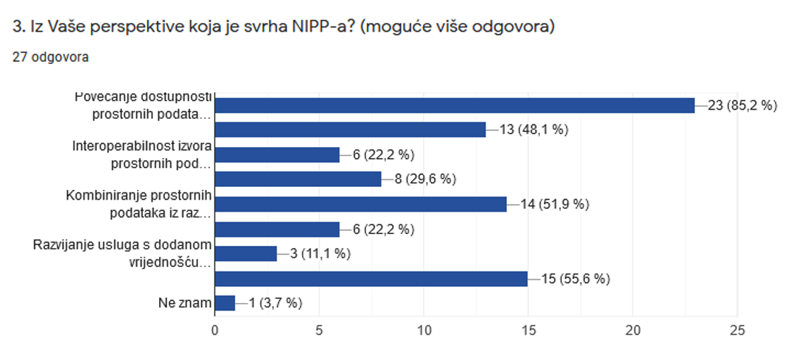
The answers to the third question from the questionnaire show that participants have a good understanding of the purpose of NSDI after the introductory lecture, including increasing the availability of spatial data, the possibility of combining spatial data from different sources and developing value-added services from third parties. Participants' misunderstanding of the purpose of the NSDI as "the creation of a large, centralized database" was also noted, and special attention was paid to emphasize that this answer was by no means the purpose of the NSDI.
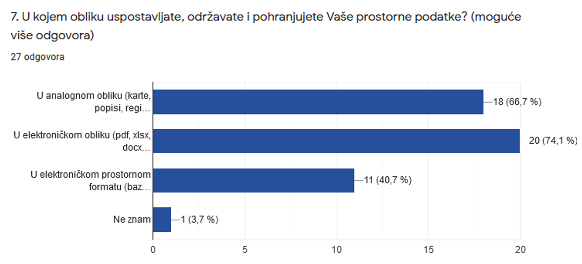
In order to ensure the future use of spatial data of public authorities, they need to meet certain conditions, one of which is to be established, maintained and stored in electronic form. The answers to 7th question covering this topic show that a large number of respondents still establish, maintain and store spatial data in an analog form.
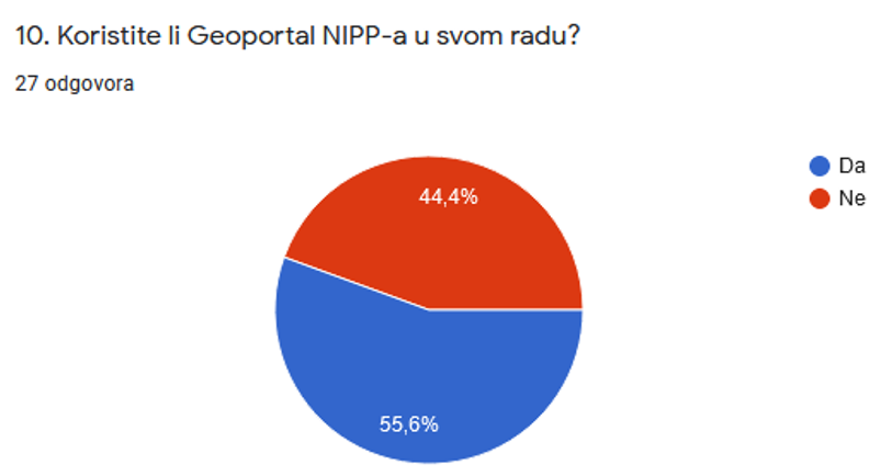
Significant answers were obtained to the tenth question from the questionnaire, which indicate poor use of NSDI products by participants. These answers confirmed the need to hold these kind of workshops, in order to expand awareness and understanding of the NSDI and its products.
Lecture "NSDI Registers" by Tanja Rodin, MsC, which followed the questionnaire, presented to the participants the legal basis and definition of NSDI subjects. The definition of spatial data has been specially elaborated in order to make it easier for the present representatives of the NSDI subjects to identify spatial data from their jurisdiction, but also to represent the obligations they are obliged to fulfill according to the NSDI Act (OG 56/13, 52/18, 50/20).
This was followed by a lecture "NSDI Metadata Catalog/NSDI Geoportal" by Iva Gašparović, PhD, who presented the NSDI Geoportal, as one of the basic products of the NSDI, whose establishment, development and maintenance are SGA’s obligation. An integral part of the NSDI Geoportal is the NSDI Metadata Catalog, in which NSDI subjects report spatial data sources from their jurisdiction and describe them with metadata.

The basics of network services and the development of network view and download services are one of the obligations of the NSDI subjects, and were presented in the lecture "Network Services" by Tanja Rodin, MsC.
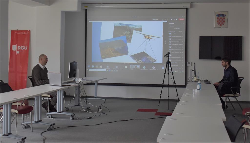
One of the goals of the NSDI is the use of interoperable services so that the spatial data they serve can be combined for various purposes, and to make them available to the general public. For this purpose, the SGA developed the GeoHrvatska browser, presented through the lecture "GeoHrvatska" by Iva Gašparović, PhD.
The State Geodetic Administration is also planning the third cycle of workshops intended primarily for NSDI subjects, which will be focused on practical work with metadata in the Metadata Catalog on the NSDI Geoportal.
| 28th NSDI WORKSHOP PROGRAM | ||
| TIME | AUTHORS AND PRESENTATION TITLES | FORMAT |
| 9:30-9:35 |
Workshop opening (Damir Šantek, PhD, SGA director general) |
|
| 9:35-9:40 | Introduction to the workshop (Ljerka Marić, MSc, and Tomislav Ciceli, MSc) | |
| 9:40-10:20 | Introduction to the NSDI; Anyone can easily find, understand and use spatial data (Tomislav Ciceli, MSc) | |
| 10:20-10:30 | Interaction with participants | |
| 10:30-10:40 | NSDI Registers (Tanja Rodin, MSc) | |
| 10:40-10:55 | NSDI Metadata Catalog/NSDI Geoportal (Iva Gašparović, PhD) | |
| 10:55-11:05 | Network services (Tanja Rodin, MSc) | |
| 11:05-11:15 | GeoHrvatska (Iva Gašparović, PhD) | |
| 11:15-11:25 | Discussion | |
| 11:25-11:30 | Workshop closing | |
Access to the NSDI website from which it is possible to download forms for the purposes of project implementation (all forms are in Croatian language).
