


The workshop was opened by Damir Šantek, PhD, director general of the State Geodetic Administration, who presented the competence of the State Geodetic Administration over spatial data that include data from the real estate cadastre and infrastructure cadastre as those closest to most subjects. He especially emphasized the competence of the State Geodetic Administration over all spatial data of the Republic of Croatia as determined by the INSPIRE Directive and the NSDI Act (OG 56/13, 52/18, 50/20).
The participants were then addressed by Ljerka Marić, MSc, Head of the Spatial Data Infrastructure Sector, who pointed out the basic goal of the NSDI: to make spatial data under the jurisdiction of the NSDI subjects available in an interoperable way, so that both citizens and the private sector can benefit from it for reuse. The participants were also greeted by Tomislav Ciceli,MSc, Head of the NSDI Service, who briefly presented the basic elements of the project and the workshop program.
The first lecture entitled “Introduction to NSDI; Anyone can easily find, understand and use spatial data" was held by Tomislav Ciceli, MSc. This lecture was aimed at reviewing the past and future development of the NSDI, getting acquainted with its goals and purpose, but also with the obligations that the NSDI subjects are required to fulfill under the NSDI Act. Finally, the importance of cooperation between local and regional self-government units as NSDI subjects and the State Geodetic Administration as National Contact Points for NSDI was emphasized in order to make spatial data available to as many citizens as possible and to use them as much as possible, and to fulfill the vision of the NSDI "Anyone can easily find, understand and use spatial data".
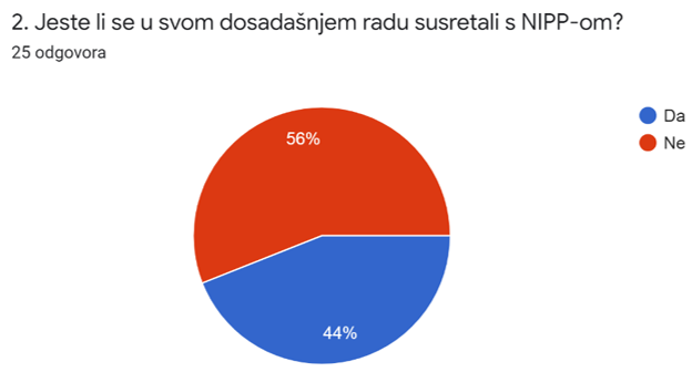
An integral part of the workshop was the interaction with the participants that followed, realized through a short questionnaire. The questionnaire was aimed at understanding the basics and purpose of the NSDI, as well as at knowing the spatial data within the jurisdiction of the NSDI subjects. The answers showed that a large number of participants have not met with the NSDI in their work so far, which confirmed the need for holding this kind and similar workshops.
 |
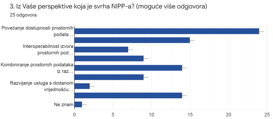
After the lecture, the participants showed a good understanding of the purpose and benefits of NSDI, where Tomislav Ciceli, MSc, especially referred to one of the frequent wrong answers, and that is the purpose of NSDI as "the creation of a large, centralized database."
 |
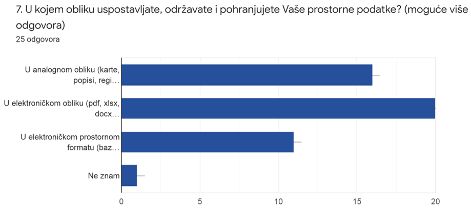
Special attention was dedicated to the issue of the form of establishment, maintenance and storage of the spatial data within the jurisdiction of the NSDI subjects. The responses obtained showed that a large number of participants still maintain spatial data in analog form.
The picture shows the answers to question 7 from the questionnaire which show that a large number of local and regional self-government units continues to establish, maintain and store spatial data from their jurisdiction in an analogue form. |
 |
The next lecture entitled "NSDI Registers" was given by Tanja Rodin, MSc. She presented to the participants the first step in joining the NSDI - registration in the Register of NSDI subjects and in the Register of NSDI spatial data sources. The definitions of NSDI subjects as public authorities and spatial data within their jurisdiction according to the NSDI Act were presented and explained.
Iva Gašparović, PhD, through the lecture "NSDI Metadata Catalog/NSDI Geoportal" explained the procedure for reporting spatial data sources from the jurisdiction of the NSDI subjects to the NSDI Metadata Catalog, which is an integral part of the NSDI Geoportal.
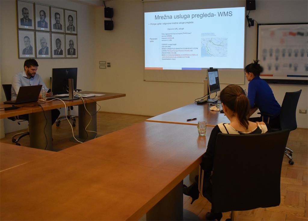
Lecture "Network Services" by Tanja Rodin, MSc, was focused on getting acquainted with INSPIRE network services and obligations of the NSDI subjects that include their development and implementation as defined by the implementing rules.
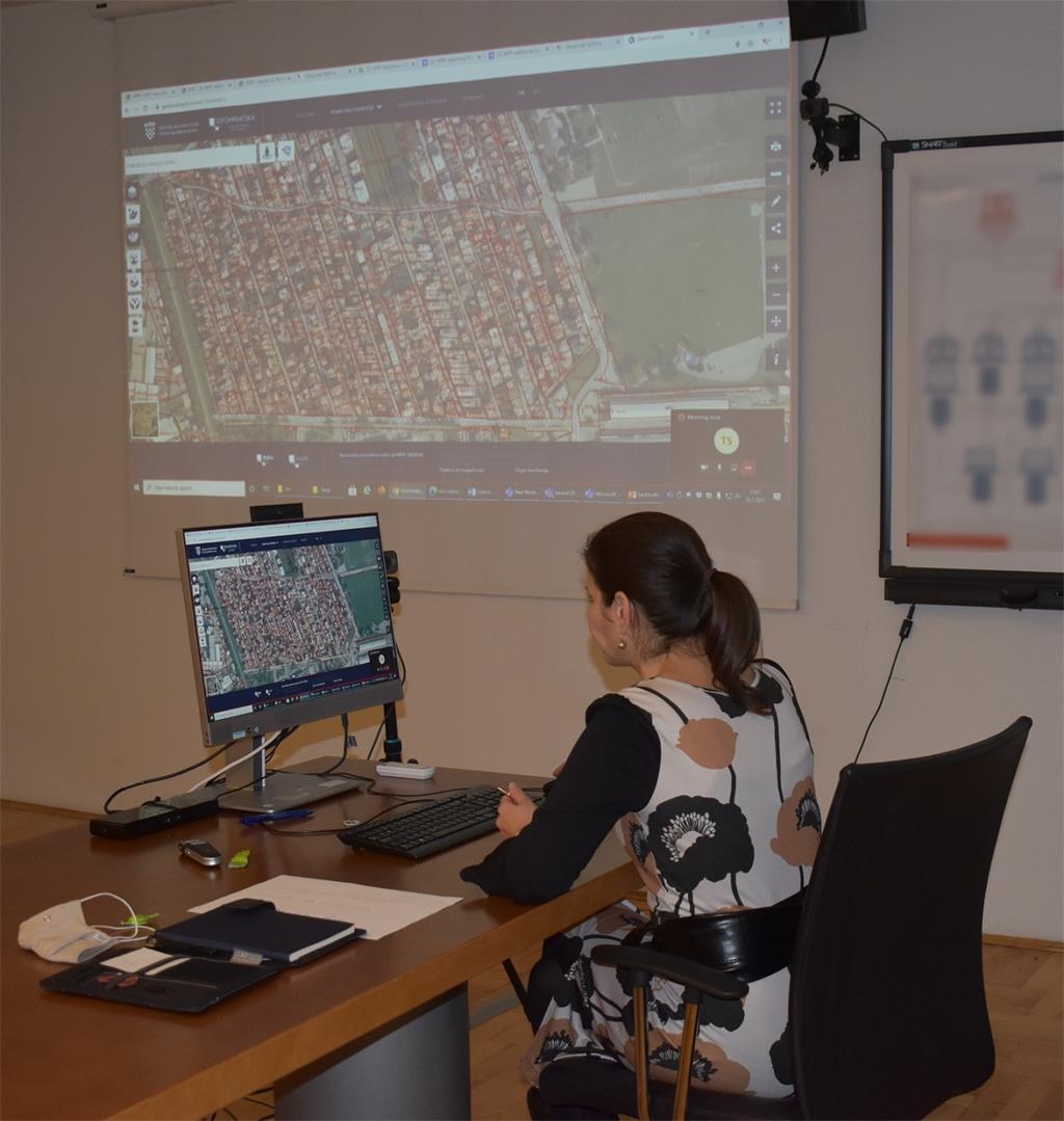
The last lecture of Iva Gašparović, PhD, "GeoHrvatska" was intended to present the GeoHrvatska browser. This browser, which is established, developed and maintained by the State Geodetic Administration, is intended for citizens, so that they can use the official spatial data of the public authorities of the Republic of Croatia.
| 22nd NSDI WORKSHOP PROGRAM | ||
| TIME | AUTHORS AND PRESENTATION TITLES | FORMAT |
| 10:00–10:05 |
Workshop opening (Damir Šantek, PhD, SGA Director General) |
|
| 10:05–10:15 | Introduction to the workshop (Ljerka Marić, MSc, and Tomislav Ciceli, MSc) | |
| 10:15–10:55 | Introduction to the NSDI; Anyone can easily find, understand and use spatial data (Tomislav Ciceli, MSc) | |
| 10:55–11:10 | Interaction with participants | |
| 11:10–11:30 | NSDI Registers (Tanja Rodin, MSc) | |
| 11:30–11:40 | Pause | |
| 11:40–12:05 | NSDI Metadata Catalog/NSDI Geoportal (Iva Gašparović, PhD) | |
| 12:05–12:30 | Network services (Tanja Rodin, MSc) | |
| 12:30–12:40 | GeoHrvatska (Iva Gašparović, PhD) | |
| 12:40–13:00 | Discussion | |
| 13:00 | Workshop closing | |
