

On February 3, the 20th NSDI workshop was held in the form of a webinar through the virtual platform Microsoft Teams. The workshop was organized by the State Geodetic Administration as the National Contact Point of the National Spatial Data Infrastructure (NSDI) within the implementation of the project "Capacity building for the establishment of the NSDI", which is co-financed by the European Social Fund.

The workshop was opened by Antonio Šustić, deputy director general of the State Geodetic Administration, who greeted all present and briefly described the beginning and development of the legislative basis of NSDI in the Republic of Croatia, realized through the State Survey and Real Estate Cadastre Act from 2007, ie the current NSDI Act and its amendments (OG 56/13, 52/18, 50/20).

The participants of the workshop were then greeted by Ljerka Marić, MSc, Head of the Spatial Data Infrastructure Sector, who presented the SDI Sector and its internal organizational units, especially the NSDI Service, responsible for the implementation of the NSDI Act and coordination of NSDI implementation and development in the Republic of Croatia. She also pointed out the basic goal of the NSDI: to make spatial data within the jurisdiction of NSDI subjects available to both citizens and the private sector, and to enable the re-use of spatial data. Those present were then greeted by Tomislav Ciceli, MSc, who presented the program of the workshop, and then the ESF project "Capacity bulding for the establishment of NSDI" within which the workshop is being held, its elements and basic objectives.

The opening of the workshop was followed by a lecture by Tomislav Ciceli, MSc: “Introduction to NSDI; Anyone can easily find, understand and use spatial data." This lecture included a detailed overview of the development of spatial data and their life cycle, as well as the established legal, strategic, technical and time frame for the establishment, maintenance and development of NSDI. Special attention was given to the development of NSDI products, with special emphasis on raising quality, as opposed to raising the quantity as has been done so far.
In order to get feedback from the participants, a short questionnaire was conducted. This questionnaire contained basic questions about the sources of spatial data in the competence of NSDI subjects, as well as questions focused on the level of understanding of NSDI and its products. The answers showed a good understanding of NSDI after the introductory lecture, but also a somewhat weaker use of NSDI products, which indicates the need to hold this type of workshops.
The picture shows the answers obtained to the 3rd question from the questionnaire. The answers obtained indicate a good understanding of the purpose of the NSDI by the workshop participants. |
 |
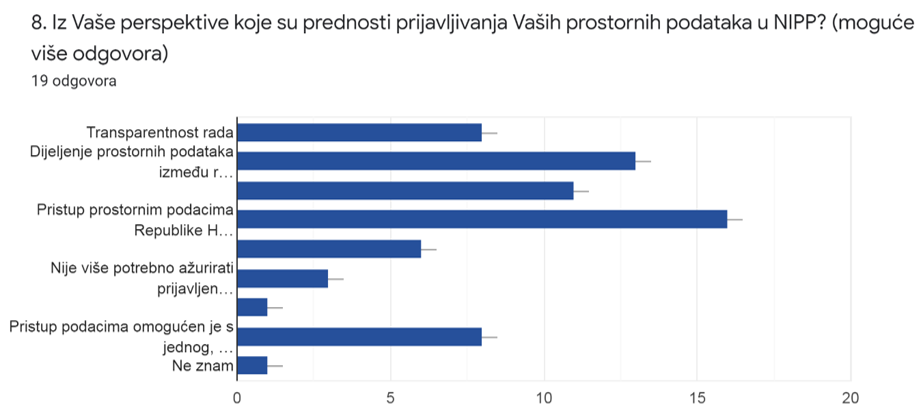
The picture shows the answers obtained to the 8th question from the questionnaire. The obtained answers indicate a good understanding of the advantages of including spatial data in the NSDI by the workshop participants. |
 |
The picture shows the answers obtained to the 2nd question from the questionnaire. Out of a total of 32 responses, 31.6% of participants have not encountered NSDI in their work so far. |
 |
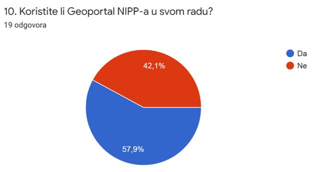
The picture shows the answers obtained to the 10th question from the questionnaire. Out of a total of 32 responses, 42.1% of participants do not use the NSDI Geoportal in their work. |
 |
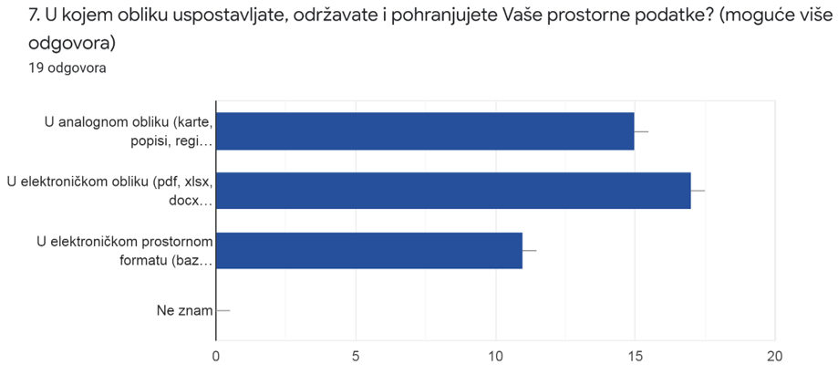
The results of the questionnaire also show that a large number of local and regional self-government units continue to establish, maintain and store spatial data from their jurisdiction in analog form. Such a way of maintaining spatial data is an obstacle to inclusion in the NSDI, but also an obstacle to the use of such spatial data.
The picture shows the answers obtained to question 7 of the questionnaire. The obtained answers indicate that a large number of participants continue to establish, maintain and store spatial data from their jurisdiction in analog form. |
 |
Then, a lecture by Tanja Rodin, MSc, "NSDI Registers" followed. This lecture was focused on the first step in the inclusion of local and regional self-government units in the NSDI, which consists of registration in the Register of NSDI subjects and registration in the Register of NSDI spatial data sources. The legal basis for the registration was explained, as well as the jurisdiction over spatial data sources.
In the next lecture "NSDI Metadata Catalog/NSDI Geoportal", Iva Gašparović, PhD, presented the NSDI Geoportal, its possibilities and components, the main of which is the Metadata Catalog. The basic elements of metadata were presented in order to facilitate the process of inclusion in the NSDI for local and regional self-government units.
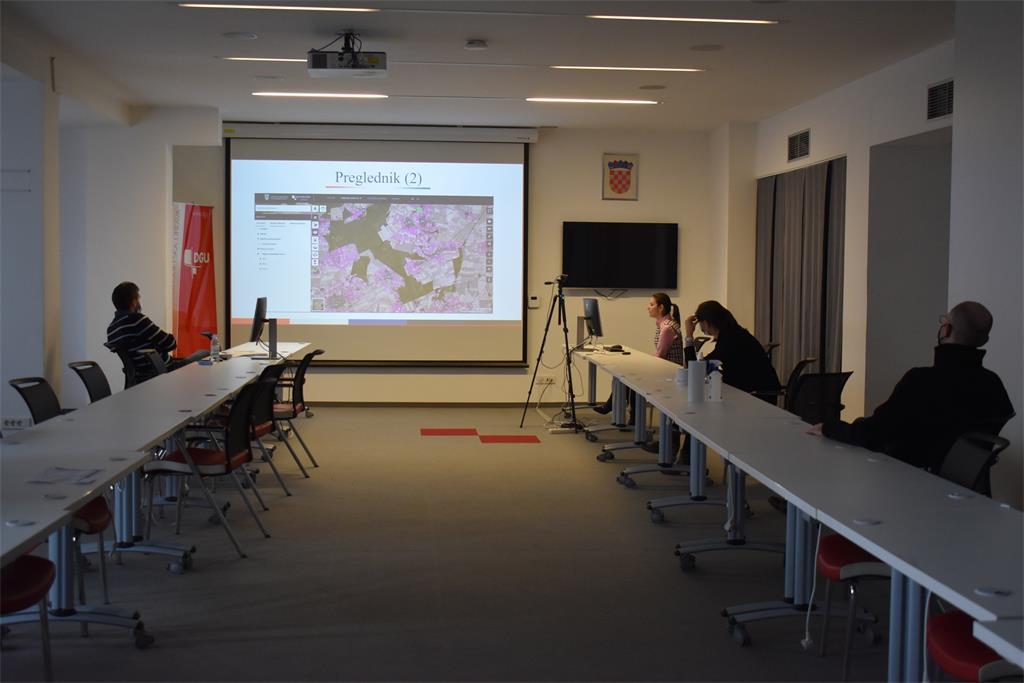
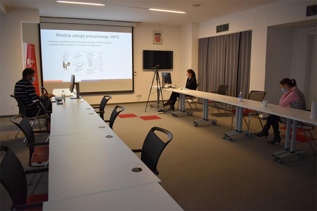
Lecture "Network Services" by Tanja Rodin, MSc, included an overview of the types of network services, with special reference to INSPIRE network services, which NSDI subjects are obliged to develop for registered sets or series of spatial data sets in their jurisdiction. At the very end, Iva Gašparović, PhD, presented the GeoHrvatska browser, which is a practical application of the NSDI intended for the general population.
| 20th NSDI WORKSHOP PROGRAM | ||
| TIME | AUTHORS AND PRESENTATION TITLES | FORMAT |
| 10:00–10:05 | Workshop opening (Antonio Šustić, deputy director general) | |
| 10:05–10:15 | Introduction to the workshop (Ljerka Marić, MSc, and Tomislav Ciceli, MSc) | |
| 10:15–10:55 | Introduction to the NSDI; Anyone can easily find, understand and use spatial data (Tomislav Ciceli, MSc) | |
| 10:55–11:10 | Interaction with participants | |
| 11:10–11:30 | NSDI Registers (Tanja Rodin, MSc) | |
| 11:30–11:40 | Pause | |
| 11:40–12:05 | NSDI Metadata Catalog/NSDI Geoportal (Iva Gašparović, PhD) | |
| 12:05–12:30 | Network services (Tanja Rodin, MSc) | |
| 12:30–12:40 | GeoHrvatska (Iva Gašparović, PhD) | |
| 12:40–13:00 | Discussion | |
| 13:00 | Workshop closing | |
Access to the NSDI website from which it is possible to download forms for the purposes of project implementation (all forms are in Croatian language).
