


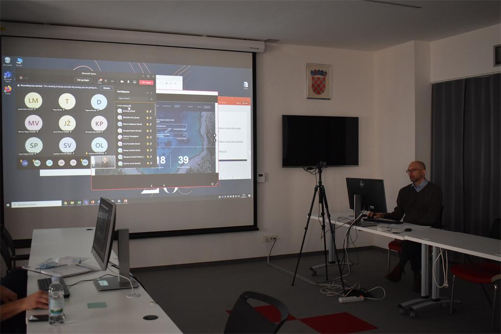
The workshop was opened by Ljerka Marić, MSc, who on this occasion presented the SGA and the activities within its jurisdiction. In particular, she referred to the NSDI Act (56/13, 52/18, 50/20) which transposed the INSPIRE Directive into Croatian legislation, as well as the obligations arising from it. In addition, she stressed that the main goal of the above Act is to make spatial data within the jurisdiction of NSDI subjects available, which requires the cooperation of local and regional self-government units as NSDI subjects and the State Geodetic Administration. Those present were greeted also by Tomislav Ciceli, MSc, who presented the program of the 21st NSDI workshop, and then the project "Capacity building for the establishment of the NSDI" which is co-financed by the European Social Fund, within which this workshop was held. The goal of this project is to increase the number of NSDI subjects, and for this purpose a new cycle of workshops was launched, within which this NSDI workshop was held.

The first lecture entitled “Introduction to NSDI; Anyone can easily find, understand and use spatial data" was held by Tomislav Ciceli, MSc. This lecture was dedicated to the ways of the establishment and requirements for the maintenance and further development of the NSDI. Considering modern technologies of spatial data collection, a large amount of spatial data (Big Data) is emphasized, the availability of which is needed in real time, which cannot be achieved by transfer via USB, DVD and similar devices, but it is necessary to develop interoperable network services that are mandatory for NSDI subjects under the NSDI Act.
This was followed by a short questionnaire in which participants answered questions about knowledge of the NSDI and spatial data from the jurisdiction of local and regional self-government units. The obtained answers showed that a large number of participants have not encountered NSDI so far, and that a large number of them do not use the NSDI Geoportal in their work. This result confirmed the need for holding a new cycle of workshops, in order to familiarize NSDI subjects with new NSDI products and their possibilities.
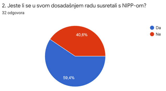
The picture shows the answers obtained to the 2nd question from the questionnaire. Out of a total of 32 answers received, 40.6% of participants have not encountered NSDI in their work so far. |
 |
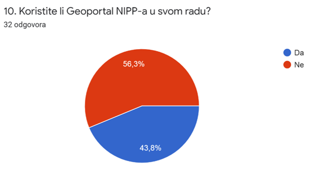
The picture shows the answers obtained to the 10th question from the questionnaire. Out of a total of 32 responses, 56.3% of participants do not use the NSDI Geoportal in their work. |
 |
The questionnaire was followed by a lecture by Tanja Rodin, MSc, "NSDI Registers", which included an explanation of certain provisions of the NSDI Act that relate to the definitions of NSDI subjects as public authorities and the definitions of spatial data themselves. An overview of the framework list of spatial data topics under the jurisdiction of local and regional self-government units and the legal basis over them is given. These definitions are necessary in order to be able to clearly define the jurisdiction of NSDI subjects.
In the lecture "NSDI Metadata Catalog / NSDI Geoportal", Iva Gašparović, PhD, presented the constituent functionalities of the NSDI Geoportal which is established, maintained and developed by the State Geodetic Administration as the National Contact Point for NSDI. One of its constituent parts is the Metadata Catalog, the elements of which were explained in detail, so that NSDI subjects can successfully complete the final step in inclusion in the NSDI - registering spatial data sources from their jurisdiction to the NSDI.

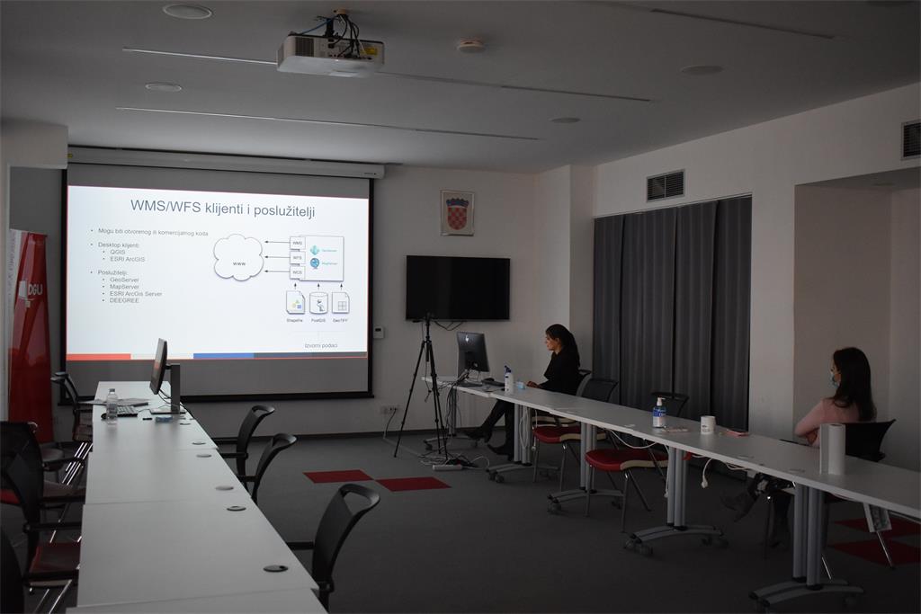
Through the lecture "Network Services" Tanja Rodin, MSc, explained INSPIRE network services and the standards used in their implementation to ensure the interoperability of services, as well as the availability and up-to-dateness of spatial data, to which NSDI subjects are required under the NSDI Act.
The final lecture "GeoHrvatska" was held by Iva Gašparović, PhD, who presented the GeoHrvatska browser as a new product of the State Geodetic Administration, intended for citizens, which is currently in the trial phase.
| 21st NSDI WORKSHOP PROGRAM | ||
| TIME | AUTHORS AND PRESENTATION TITLES | FORMAT |
| 10:00–10:05 | Workshop opening (Ljerka Marć, MSc) | |
| 10:05–10:15 | Introduction to the workshop (Ljerka Marić, MSc, and Tomislav Ciceli, MSc) | |
| 10:15–10:55 | Introduction to the NSDI; Anyone can easily find, understand and use spatial data (Tomislav Ciceli, MSc) | |
| 10:55–11:10 | Interaction with participants | |
| 11:10–11:30 | NSDI Registers (Tanja Rodin, MSc) | |
| 11:30–11:40 | Pause | |
| 11:40–12:05 | NSDI Metadata Catalog/NSDI Geoportal (Iva Gašparović, PhD) | |
| 12:05–12:30 | Network services (Tanja Rodin, MSc) | |
| 12:30–12:40 | GeoHrvatska (Iva Gašparović, PhD) | |
| 12:40–13:00 | Discussion | |
| 13:00 | Workshop closing | |
