

As the National Contact Point for NSDI, the State Geodetic Administration initiated a series of activities aimed at expanding knowledge in order to effectively involve local and regional self-government units in the NSDI, and one of the basic activities was holding workshops. Thus, in the period from February to May 2021, a total of 11 NSDI workshops was held with the participation of representatives from 247 different local and regional self-government units.


The 31st NSDI workshop was opened by Antonio Šustić, Deputy Director General of the State Geodetic Administration, who on this occasion presented the State Geodetic Administration as one of the 12 administrative organizations in the Republic of Croatia responsible for the National Spatial Data Infrastructure. He pointed out that one of the main goals of the NSDI is to provide the highest quality services. For this purpose, the SGA is making efforts to make the spatial data of the public authorities of the Republic of Croatia available not only to professional users, but also to citizens. I order to achieve that, the State Geodetic Administration establishes and develops the GeoHrvatska browser, which is intended for citizens.

Those present were then greeted by Ljerka Marić, MsC, Head of the Spatial Data Infrastructure Sector, within which the activities of coordination of the establishment of the NSDI in the Republic of Croatia are being implemented. She also emphasized the obligation of inclusion in the NSDI as defined by the NSDI Act, which transposed the INSPIRE Directive into Croatian legislation, and is binding for all EU member states. This was followed by the presentation of the program of the 31st NSDI workshop, as well as of the project "Capacity building for the establishment of the NSDI" by the project manager, Tomislav Ciceli, MsC.
Tomislav Ciceli, MsC, held the first from a series of lectures entitled "Introduction to NSDI; anyone can easily find, understand and use spatial data”. This lecture included a thorough overview of the establishment, development and maintenance of the NSDI in the Republic of Croatia through the legal, strategic, time and technical framework. Special attention was given to the understanding and use of spatial data, as well as the NSDI itself, especially seen from the perspective of recent events (floods, fires, earthquakes, epidemics). The growing presence of a wide range of different new methods of collecting spatial data, which result in extremely large amounts of spatial data, was also emphasized. In order for them to be available, and to be able to be used and combined multiple times, it is necessary to establish a spatial data infrastructure.
The introductory lecture was followed by an interaction with the participants, realized through a short, anonymous questionnaire, the results of which indicated the need for holding this kind and similar workshops, in order to successfully use the NSDI and its products (NSDI Registers, NSDI Geoportal, GeoHrvatska browser).
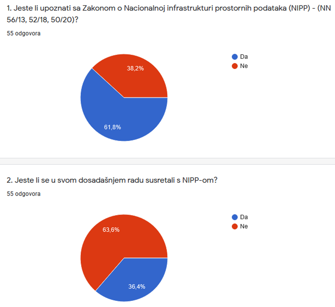

Significant answers were obtained to question 7 of the questionnaire, which show that out of a total of 55 respondents, 35 of them (63.6%) still establish, maintain and store spatial data from their jurisdiction in an analog form.

Lecture by Tanja Rodin, MsC, entitled "NSDI Registers", presented the establishment and maintenance of the NSDI Registers (Register of NSDI Subjects and Register of NSDI Spatial Data Sources), as well as their content, as prescribed by the NSDI Act. As the NSDI Registers represent the first step in the inclusion in the National Spatial Data Infrastructure, this lecture presented the entire procedure, with previous definitions of spatial data and descriptions of NSDI themes, so that the representatives of the local and regional self-government units can independently distinguish their jurisdiction over spatial data.
This was followed by a lecture "NSDI Geoportal/NSDI Metadata Catalog" by Tanja Rodin, MsC, who through this lecture introduced to the attendees the next step in inclusion in the NSDI. Thus, one of the basic products of the NSDI was presented - the NSDI Geoportal - together with its basic elements and functionalities. In order to make it easier for the representatives of local and regional self-government units to enter metadata for spatial data sources from their jurisdiction, on a practical example entering of metadata was shown, with an explanation of metadata elements.
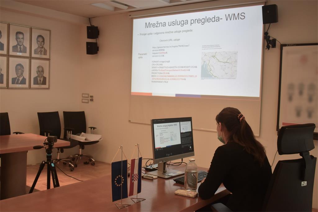
Lecture "Network Services" by Tanja Rodin, MsC, covered the basics of network services, the development of which is an obligation for NSDI subjects under the NSDI Act. The available standards for the implementation of network services were presented, as well as their most frequently used clients and servers.
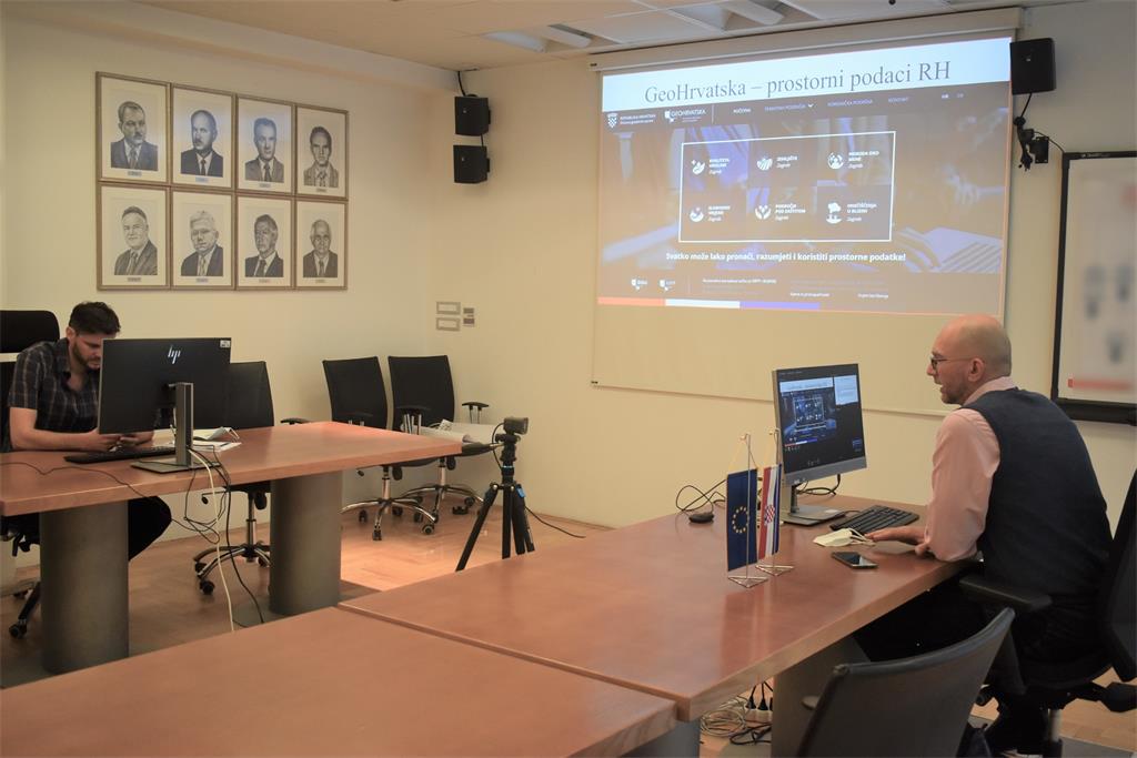
The last lecture "GeoHrvatska" was given by Tomislav Ciceli, MsC. This lecture presented the GeoHrvatska browser, which is intended for citizens. The GeoHrvatska browser is one of the basic products of the NSDI, and it represents a unified place where spatial data of the NSDI subjects can be visualized.
| 31st NSDI WORKSHOP PROGRAM | ||
| TIME | AUTHORS AND PRESENTATION TITLES | FORMAT |
| 9:30-9:35 |
Workshop opening (Antonio Šustić, SGA deputy director general) |
|
| 9:35-9:40 | Introduction to the workshop (Ljerka Marić, MSc, and Tomislav Ciceli, MSc) | |
| 9:40-10:20 | Introduction to the NSDI; Anyone can easily find, understand and use spatial data (Tomislav Ciceli, MSc) | |
| 10:20-10:30 | Interaction with participants | |
| 10:30-10:40 | NSDI Registers (Tanja Rodin, MSc) | |
| 10:40-10:55 | NSDI Metadata Catalog/NSDI Geoportal (Iva Gašparović, PhD) | |
| 10:55-11:05 | Network services (Tanja Rodin, MSc) | |
| 11:05-11:15 | GeoHrvatska (Iva Gašparović, PhD) | |
| 11:15-11:25 | Discussion | |
| 11:25-11:30 | Workshop closing | |
Access to the NSDI website from which it is possible to download forms for the purposes of project implementation (all forms are in Croatian language).
